2024 Research: Year in Review
Advancing Geospatial Analysis, Flood Modelling and Mapping for Climate Resilience
 Sample image from pluvial flood modelling project
In recent years, I had the chance to collaborate with talented research teams and academic partners across Canada. This work culminated in a number of publicly available, peer-reviewed journal articles in 2024. This blog post outlines some of the key research outputs from these articles. Looking forward to another fruitful and productive year!

1. Large-scale flood modelling based on LiDAR data: a case study in the Southwest Miramichi watershed, New Brunswick, Canada
Journal: Canadian Water Resources Journal (Dec 2024)
- This study addresses Canada’s flood mapping challenges by developing a cost-effective LiDAR-based method that estimates river bathymetry using Manning’s equation and water surface slope, tested across 512 km of New Brunswick’s Miramichi watershed.
- The approach achieved high accuracy with 1 hour/km processing efficiency, demonstrating viability for large-scale applications where traditional bathymetry collection is impractical.

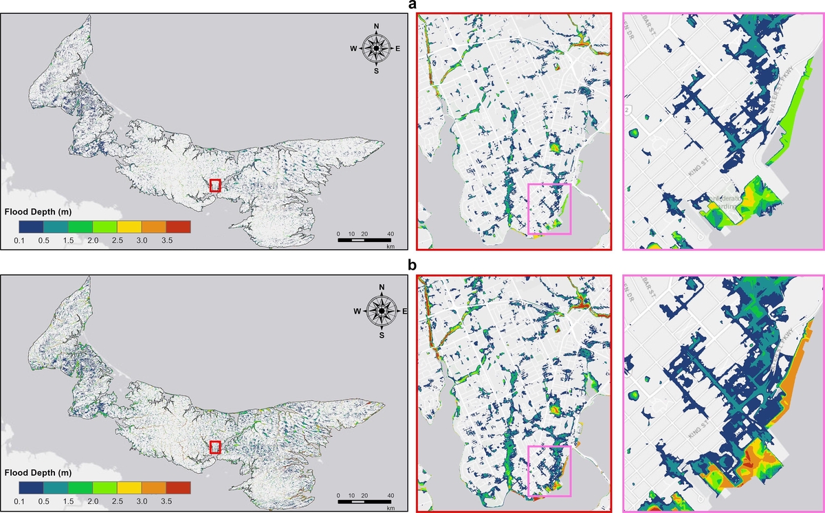
2. Pluvial flood modeling for coastal areas under future climate change – A case study for Prince Edward Island, Canada
Journal: Journal of Hydrology (Sep 2024)
- This study developed a comprehensive pluvial flood model for Prince Edward Island to address the complex challenges of compound flooding in coastal communities.
- The model combines Intensity-Duration-Frequency curves under current and future climate scenarios with HEC-RAS 2D rain-on-grid (RoG) hydraulic modeling to produce validated pluvial flood maps for both municipal and island-wide planning.

3. Post-wildfire boreal forest vegetation cover change mapping via information fusion for secondary disaster risk assessments
Journal: IJAG (Sep 2024)
- This study developed an information fusion framework combining Landsat8 and WorldView imagery to map post-wildfire vegetation changes around Fort McMurray, Alberta, addressing the critical need to assess secondary disaster risks in wildfire-affected regions near human settlements.
- The results revealed that WorldView data provided superior detail in vegetation burn damage assessment compared to traditional Landsat-based dNBR indices, while identifying important limitations in burn severity measurements due to rapid herbaceous recovery. These findings can be used in post-wildfire hazard assessments, such as flood hazard.

4. A rapid high-resolution multi-sensory urban flood mapping framework via DEM upscaling
Journal: Remote Sensing of Environment (Feb 2024)
- This research addresses urban flood mapping challenges by developing a novel multi-sensory framework that combines DEM upscaling, flood segmentation from optical imagery, and GIS-based flood extent estimation.
- The framework uses deep learning to generate high-resolution (2m) DEMs from low-resolution (18m) data, while requiring only 10% of human labeling for flood segmentation training.
- When validated on Calgary’s 2013 flood event, the system achieved over 80% intersection-over-union accuracy in visible flood extraction and demonstrated significant improvements over conventional flood mapping methods.
Explore all publications via their DOI links above, or contact me for full-text requests.
Maxim Fortin
Water Resources Engineer
My professional interests include hydrological and hydraulic modeling, flood mapping and geospatial data analysis.