Global Flood Partnership: Flood Hazards in Canada: Update from the National Flood Mapping Program
 Flood Hazards in Canada: Update from the National Flood Mapping Program
Abstract
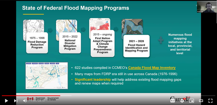
Since 2021, the Government of Canada has invested $63.8M in the Flood Hazard Identification and Mapping Program (FHIMP) to help Canadians better plan and prepare for future flood risks. In this presentation, Natural Resources Canada (NRCan) will provide an update on current activities in support of flood mapping, followed by Environment and Climate Change Canada (ECCC) providing and update on Climate, meteorological and hydrological research and developments to improve flood hazard maps. Discussion will include the current state of flood mapping in the country, the key challenges faced, research and development (R&D) activities currently underway, as well as an update on the FHIMP: a joint initiative led by NRCan and supported by Public Safety Canada and Environment and Climate Change Canada. This program aims to produce flood hazard data and maps for high-risk areas across the country by actively collaborating with provincial and territorial jurisdictions. Perspectives on lessons learned and the future of the program will be discussed, as well as updates on the progress of various other federal initiatives in support of flood mapping.
Global Flood Partnership Webinar - National and Global Flood Inundation Mapping Systems
“We are thrilled to announce our upcoming GFP Webinar on February 21, 2024. This event will feature three exciting presentations from distinguished experts in the field, focusing on operational flood inundation mapping systems.”
Webinar details:
- Date: February 21, 2024
- Time: 9:00 AM US Eastern Standard Time
- Duration: 1.5 hours
Presentation Details:
Title: Flood Hazards in Canada: Update from the National Flood Mapping Program
Presenters: Maxim Fortin, Natural Resources Canada and Katie Slimmon, Environment and Climate Change Canada
Abstract: Since 2021, the Government of Canada has invested $63.8M in the Flood Hazard Identification and Mapping Program (FHIMP) to help Canadians better plan and prepare for future flood risks. In this presentation, Natural Resources Canada (NRCan) will provide an update on current activities in support of flood mapping, followed by Environment and Climate Change Canada (ECCC) providing and update on Climate, meteorological and hydrological research and developments to improve flood hazard maps. Discussion will include the current state of flood mapping in the country, the key challenges faced, research and development (R&D) activities currently underway, as well as an update on the FHIMP: a joint initiative led by NRCan and supported by Public Safety Canada and Environment and Climate Change Canada. This program aims to produce flood hazard data and maps for high-risk areas across the country by actively collaborating with provincial and territorial jurisdictions. Perspectives on lessons learned and the future of the program will be discussed, as well as updates on the progress of various other federal initiatives in support of flood mapping.
Title: Operational Flood Inundation Prediction and Monitoring at Global Scale using Modeling and Satellite Data
Presenters: Peter Salamon, Joint Research Center, European Commission
Abstract: The Copernicus Emergency Management Service provides operational flood inundation mapping and monitoring data using modeling and satellite data through its Global Flood Awareness System and the Global Flood Monitoring product. The presentation illustrates the procedures and processes for the forecast-based rapid flood mapping products as well as the satellite based monitoring of flood extent, outlines its advantages and limitations, and presents some real-world use cases.
Title: Development and Operational Deployment of Forecast Flood Inundation Mapping at Continental Scale
Presenters: Jason Elliott and Derek Giardino, NOAA Office of Water Prediction, USA
Abstract: The National Water Center is developing and deploying flood information mapping forecasts and analysis for the United States. This presentation provides an overview of the current and planned state of flood inundation mapping development and operational deployment as well as practical application examples.
Maxim Fortin
Water Resources Engineer
My professional interests include hydrological and hydraulic modeling, flood mapping and geospatial data analysis.