Pluvial flood modeling for coastal areas under future climate change – A case study for Prince Edward Island, Canada
Abstract
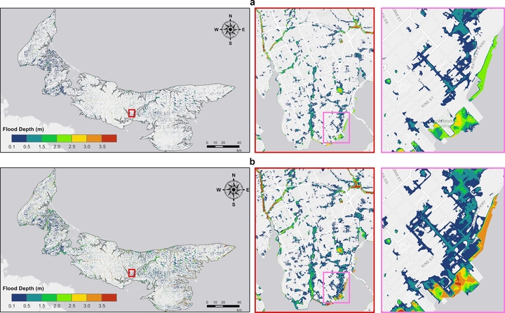
It has been increasingly understood that pluvial flooding poses a substantial risk to numerous communities across the globe. This is especially relevant for the Canadian province of Prince Edward Island (PEI), which is susceptible to a compound flood consisting of both inland and coastal flooding. Despite various studies, a comprehensive pluvial flood model still lacks that addresses the complex interplay of compound floods. Therefore, this research aims to bridge the gap in flood mitigation by developing a pluvial flood model for PEI’s coastal communities. The Intensity-Duration-Frequency (IDF) curves under current and future climatic conditions were used to portray rainfall intensity over the study area corresponding to 10-year, 25-year, 50-year, and 100-year return periods. In addition, a hydraulic model (HEC-RAS 2D) was used to drive pluvial flood maps based on two configurations, including detailed flood maps for major municipalities and an island-wide level. The validated results showed consistency in model simulation when compared to observations. The high-resolution flood maps produced by this study can support the development of flood mitigation and adaptation strategies in PEI and other parts of the world.
Pluvial flood modeling for coastal areas under future climate change – A case study for Prince Edward Island, Canada
07 August 2024
Authors: Quan Van Dau, Xiuquan Wang, Farhan Aziz, Rana Ali Nawaz, Tianze Pang, Muhammad Qasim Mahmood & Maxim Fortin
Maxim Fortin
Water Resources Engineer
My professional interests include hydrological and hydraulic modeling, flood mapping and geospatial data analysis.